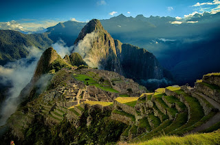
Machu Picchu (Spanish pronunciation) is a 15th-century Inca
citadel situated on a mountain ridge 2,430 metres (7,970 ft) above sea level.It
is located in the Cusco Region, Urubamba Province, Machupicchu District in Peru
above the Sacred Valley, which is 80 kilometres (50 mi) northwest of Cuzco and
through which the Urubamba River flows.
Most archaeologists believe that Machu Picchu was built as
an estate for the Inca emperor Pachacuti (1438–1472). Often mistakenly referred
to as the "Lost City of the Incas" (a title more accurately applied
to Vilcabamba), it is the most familiar icon of Inca civilization. The Incas
built the estate around 1450 but abandoned it a century later at the time of
the Spanish Conquest. Although known locally, it was not known to the Spanish
during the colonial period and remained unknown to the outside world until
American historian Hiram Bingham brought it to international attention in 1911.
Machu Picchu was built in the classical Inca style, with
polished dry-stone walls. Its three primary structures are the Inti Watana, the
Temple of the Sun, and the Room of the Three Windows. Most of the outlying
buildings have been reconstructed in order to give tourists a better idea of how
they originally appeared.By 1976, thirty percent of Machu Picchu had been
restored and restoration continues.
Machu Picchu was declared a Peruvian Historical Sanctuary in
1981 and a UNESCO World Heritage Site in 1983.In 2007, Machu Picchu was voted
one of the New Seven Wonders of the World in a worldwide Internet poll.


HISTORY
Machu Picchu was built around 1450, at the height of the
Inca.Its construction appears to date to the period of the two great Inca
rulers, Pachacutec Inca Yupanqui (1438–71) and Túpac Inca Yupanqui (1472–93).It
was abandoned just over 100 years later, in 1572, as a belated result of the
Spanish Conquest.It is possible that most of its inhabitants died from smallpox
introduced by travellers before the Spanish conquistadors arrived in the area.
Although it was located only about 80 kilometers (50 mi)
from the Inca capital in Cusco, the Spanish never found Machu Picchu and so did
not plunder or destroy it, as they did many other sites.The conquistadors had
notes of a place called Piccho, although no record of a Spanish visit exists.
The types of sacred rocks defaced by the conquistadors in other locations are
untouched at Machu Picchu.
Over the centuries, the surrounding jungle overgrew the
site, and few outside the immediate area knew of its existence. The site may
have been discovered and plundered in 1867 by a German businessman, Augusto
Berns.Some evidence indicates that German engineer J. M. von Hassel arrived
earlier. Maps show references to Machu Picchu as early as 1874.
In 1911 American historian and explorer Hiram Bingham
travelled the region looking for the old Inca capital and was shown to Machu
Picchu by a local farmer. Bingham brought Machu Picchu to international
attention and organized another expedition in 1912 to undertake major clearing
and excavation. He returned in 1914 and 1915 to continue with excavation.
In 1981, Peru declared an area of 325.92 square kilometres
(125.84 sq mi) surrounding Machu Picchu a "Historical Sanctuary". In
addition to the ruins, the sanctuary includes a large portion of the adjoining
region rich with the flora and fauna of the Peruvian Yungas and Central Andean
wet puna ecoregions.
In 1983, UNESCO designated Machu Picchu a World Heritage
Site, describing it as "an absolute masterpiece of architecture and a
unique testimony to the Inca civilization".


FIRST AMERICAN EXPEDITION
Bingham was a lecturer at Yale University, although not a
trained archaeologist. In 1909, returning from the Pan-American Scientific
Congress in Santiago, he traveled through Peru and was invited to explore the
Inca ruins at Choqquequirau in the Apurímac Valley. He organized the 1911 Yale
Peruvian Expedition in part to search for the Inca capital, which was thought
to be the city of Vitcos. He consulted Carlos Romero, a historian in Lima who
showed him helpful references and Father Calancha’s Chronicle.
Hiram Bingham III at his tent door near Machu Picchu in 1912
Armed with this information the expedition went down the
Urubamba River. En route Bingham asked local people to show them Inca ruins. By
the time they camped at Mandor Pampa, with Huayna Picchu 2000 feet above them
on the opposite bank, they had already examined several ruins, but none fit the
descriptions of Vitcos.
At Mandor Pampa, Bingham asked farmer and innkeeper Melchor
Arteaga if he knew of any nearby ruins. Arteaga said he knew of excellent ruins
on the top of Huayna Picchu.The next day, 24 July, Arteaga led Bingham and
Sergeant Carrasco across the river on a log bridge and up the Huayna Picchu
mountain. At the top of the mountain they came across a small hut occupied by a
couple of Quechua, Richarte and Alvarez, who were farming some of the original
Machu Picchu agricultural terraces that they had cleared four years earlier.
Alvarez's 11-year-old son, Pablito, led Bingham along the ridge to the main
ruins.
The ruins were mostly covered with vegetation except for the
cleared agricultural terraces and clearings used by the farmers as vegetable
gardens. Because of the vegetation Bingham was not able to observe the full
extent of the site. He took preliminary notes, measurements and photographs,
noting the fine quality of Inca stonework of several principal buildings.
Bingham was unclear about the original purpose of the ruins, but decided that
there was no indication that it matched the description of Vitcos.
The expedition continued down the Urubamba and up the
Vilcabamba Rivers examining all the ruins they could find. Guided by locals
Bingham rediscovered and correctly identified the site of the old Inca capital,
Vitcos (then called Rosaspata), and the nearby temple of Chuquipalta. He then
crossed a pass and into the Pampaconas Valley where he found more ruins heavily
buried in the jungle undergrowth at Espíritu Pampa, which he named
"Eromboni Pampa".As was the case with Machu Picchu, the site was so
heavily overgrown that Bingham could only note a few of the buildings. In 1964,
Gene Savoy further explored the ruins at Espiritu Pampa and revealed the full
extent of the site, identifying it as Vilcabamba Viejo where the Incas fled
after the Spanish drove them from Vitcos.
On the return of the expedition up the Urubamba River,
Bingham sent two men to clear and map the site he referred to as Machu Picchu.
As Bingham failed to identify the ruins at Espiritu Pampa as Vilcabamba Viejo,
he erroneously theorized that Machu Picchu was Vilcabamba Viejo. Machu Picchu
features spectacular workmanship and a dramatic site, while Vilcabamba was
built while the short-lived remnant Neo-Inca State was being vanquished by the
Spanish; it was built quickly and features crude workmanship.
Bingham returned to Machu Picchu in 1912 under the
sponsorship of Yale University and National Geographic and with full support of
Peruvian President Leguia. The expedition undertook a four-month clearing of
the site with local labor, which was expedited with the support of the Prefect
of Cuzco. Excavation started in 1912 with further excavation undertaken in 1914
and 1915. Bingham focused on Machu Picchu because of its fine Inca stonework
and well-preserved nature, which had lain undisturbed since the site was
abandoned. None of Bingham's several hypotheses explaining the site held up.
During his studies, he carried various artifacts back to Yale. One prominent
artifact was a set of 15th-century, ceremonial Incan knives made from bismuth
bronze; they are the earliest known artifact containing this alloy.
Although local institutions initially welcomed the
exploration, they soon accused Bingham of legal and cultural malpractice.Rumors
arose that the team was stealing artifacts and smuggling them out of Peru
through Bolivia. (In fact, Bingham removed many artifacts, but openly and
legally; they were deposited in the Yale University Museum.) Local press
perpetuated the accusations, claiming that the excavation harmed the site and
deprived local archaeologists of knowledge about their own history.Landowners
began to demand rent from the excavators.By the time Bingham and his team left
Machu Picchu, locals had formed coalitions to defend their ownership of Machu
Picchu and its cultural remains, while Bingham claimed the artifacts ought to
be studied by experts in American institutions.
GEOGRAPHY
Machu Picchu lies in the southern hemisphere, 13.164 degrees
south of the equator.It is 80 kilometres (50 miles) northwest of Cusco, on the
crest of the mountain Machu Picchu, located about 2,430 metres (7,970 feet)
above mean sea level over 1,000 metres (3,300 ft) lower than Cusco, which has
an elevation of 3,600 metres (11,800 ft).As such, it had a milder climate than
the Inca capital. It is one of the most important archaeological sites in South
America, one of the most visited tourist attractions in Latin America and the
most visited in Peru.
Machu Picchu has wet and dry seasons, with the majority of
annual rain falling from October through to April.
Machu Picchu is situated above a bow of the Urubamba River,
which surrounds the site on three sides, where cliffs drop vertically for 450
metres (1,480 ft) to the river at their base. The area is subject to morning mists
rising from the river.The location of the city was a military secret, and its
deep precipices and steep mountains provided natural defenses. The Inca Bridge,
an Inca grass rope bridge, across the Urubamba River in the Pongo de Mainique,
provided a secret entrance for the Inca army. Another Inca bridge was built to
the west of Machu Picchu, the tree-trunk bridge, at a location where a gap
occurs in the cliff that measures 6 metres (20 ft). It could be bridged by two
tree trunks, but with the trees removed, there was a 570 metres (1,870 ft) fall
to the base of the cliffs.
The city sits in a saddle between the two mountains Machu
Picchu and Huayna Picchu with a commanding view down two valleys and a nearly
impassable mountain at its back. It has a water supply from springs that cannot
be blocked easily, and enough land to grow food for about four times as many
people as ever lived there. The hillsides leading to it were terraced,to
provide more farmland to grow crops, and to steepen the slopes that invaders
would have to ascend. The terraces reduced soil erosion and protected against
landslides.Two high-altitude routes from Machu Picchu cross the mountains back
to Cusco, one through the sun gate, and the other across the Inca bridge.Both
could be blocked easily, should invaders approach along them.

INTI WATANA STONE
The Inti Watana stone is one of many ritual stones in South
America. These stones are arranged to point directly at the sun during the
winter solstice. The name of the stone (perhaps coined by Bingham) derives from
Quechua language: inti means "sun", and wata-, "to tie, hitch
(up)". The suffix -na derives nouns for tools or places. Hence inti watana
is literally an instrument or place to "tie up the sun", often
expressed in English as "The Hitching Post of the Sun". The Inca
believed the stone held the sun in its place along its annual path in the sky.
The stone is situated at 13°9'48" S. At midday on 11 November and 30
January, the sun stands almost exactly above the pillar, casting no shadow. On
21 June, the stone casts the longest shadow on its southern side, and on 21
December a much shorter shadow on its northern side.


CONSTRUCTION
The central buildings use the classical Inca architectural
style of polished dry-stone walls of regular shape. The Incas were masters of
this technique, called ashlar, in which blocks of stone are cut to fit together
tightly without mortar.
The section of the mountain where Machu Picchu was built
provided various challenges that the Incas solved with local materials. One
issue was the seismic activity due to two fault lines. It made mortar and
similar building methods nearly useless. Instead, the Inca mined stones from
the quarry at the site, lined them up and shaped them to fit together
perfectly, stabilizing the structures. Inca walls have many stabilizing
features: doors and windows are trapezoidal, narrowing from bottom to top;
corners usually are rounded; inside corners often incline slightly into the
rooms; and outside corners were often tied together by "L"-shaped blocks;
walls are offset slightly from row to row rather than rising straight from
bottom to top.
Heavy rainfall required terraces and stone chips to drain
rain water and prevent mud slides, landslides, erosion and flooding. Terraces
were layered with stone chips, sand, dirt and top soil, to absorb water and
prevent it from running down the mountain. Similar layering protected the large
city center from flooding.Multiple canals and reserves provide water throughout
the city that could be supplied to the terraces for irrigation and to prevent
erosion and flooding.
The Incas never used wheels in a practical way, although its
use in toys shows that they knew the principle. Its use in engineering may have
been limited due to the lack of strong draft animals, steep terrain and dense
vegetation. The approach to moving and placing the enormous stones remains
uncertain, probably involving hundreds of men to push the stones up inclines. A
few stones have knobs that could have been used to lever them into position;
after which they were generally sanded away, with a few overlooked.
ROADS AND TRANSPORTATION
The Inca road system included a route to the Machu Picchu
region. The people of Machu Picchu were connected to long-distance trade, as
shown by non-local artifacts found at the site. For example, Bingham found
unmodified obsidian nodules at the entrance gateway. In the 1970s, Burger and
Asaro determined that these obsidian samples were from the Titicaca or Chivay
obsidian source, and that the samples from Machu Picchu showed long-distance
transport of this obsidian type in pre-Hispanic Peru.
Thousands of tourists walk the Inca Trail to visit Machu
Picchu each year.They congregate at Cusco before starting on the one-, two-,
four- or five-day journey on foot from Kilometer 82 (or 77 or 85, four/five-day
trip) or Kilometer 104 (one/two-day trip) near the town of Ollantaytambo in the
Urubamba valley, walking up through the Andes to the isolated city.


TOURISM
Machu Picchu is a UNESCO World Heritage Site, both cultural
and natural. Since its discovery in 1911, growing numbers of tourists visit the
site yearly, reaching 400,000 in 2000.As Peru's most visited tourist attraction
and major revenue generator, it is continually exposed to economic and
commercial forces. In the late 1990s, the Peruvian government granted
concessions to allow the construction of a cable car and a luxury hotel,
including a tourist complex with boutiques and restaurants and a bridge to the
site.Many people protested the plans, including Peruvians and foreign
scientists, saying that more visitors would pose a physical burden on the
ruins.A no-fly zone exists above the area.UNESCO is considering putting Machu
Picchu on its List of World Heritage in Danger.
During the 1980s a large rock from Machu Picchu's central
plaza was moved to a different location to create a helicopter landing zone. In
the 1990s, the government prohibited helicopter landings. In 2006, a
Cusco-based company, Helicusco, sought approval for tourist flights over Machu
Picchu. The resulting license was soon rescinded.
Authorities have struggled to maintain tourist safety.
Tourist deaths have been linked to altitude sickness, floods and hiking
accidents.UNESCO received criticism for allowing tourists at the location given
high risks of landslides, earthquakes and injury due to decaying structures.
Nude tourism is a recent trend, to the dismay of Peruvian
officials. In several incidents, tourists were detained for posing for nude
pictures or streaking across the site. Peru's Ministry of Culture denounced
these acts for threatening Peru's cultural heritage. Cusco's Regional Director
of Culture increased surveillance to end the practice.
ENTRANCE RESTRICTIONS
In July 2011, the Dirección Regional de Cultura Cusco (DRC)
introduced new entrance rules to the citadel of Machu Picchu.The tougher
entrance rules attempted to reduce the impact of tourism. Entrance was limited
to 2,500 visitors per day, and the entrance to Huayna Picchu (within the
citadel) was further restricted to 400 visitors per day, in two time slots, at
7 and 10 AM.
In May 2012, a team of UNESCO conservation experts called
upon Peruvian authorities to take "emergency measures" to further
stabilize the site’s buffer zone and protect it from damage, particularly in
the nearby town of Aguas Calientes, which had grown rapidly.
No comments:
Post a Comment